


Description
Tahta Limanı
The work of the survey at Tahta Limanı transpired across three seasons (2015-17) and focused on four locations: 1. the stone ring fort that looms over the valley on its north slope (the North Kale), first observed by Rauh in Google earth and investigated by the survey team in 2015 and 2016. Ceramic sampling occurred in 2016 inside the fortress as well as amid some rectangular structures exposed directly below the fortress (11 sherds). 2. The dense assemblage of structures directly on the shore of the narrow bay. The adjoining buildings along the shore resemble the remains of a Roman horreum, but there are also several exposed structures behind the beach and against the base of cliffs along the north slope. The pedestrian survey team conducted systematic grab collections at a number of these loci in 2016. These were identified on a sketch map as Buildings 4 and 6; Wall Loci 1-2; Walls A and B, and Off-site Locus 1. The grab collections conducted in 2016 furnish the bulk of the materials in this database (131, predominantly Late Roman). 3. In 2017 the team briefly investigated the extensive remains of crudely built fortification walls at the crest of the ridge looming over the south side of the bay (the South Kale). Unlike the small ring fort of the North Kale, the fortification walls at the South Kale form an extensive circuit wall. Otherwise, the masonry technique of the two fortification systems match not only each other but also those previously discussed on the mainland opposite Boğsak Island and the twin ring forts on the south peaks of Dana Island. Scattered grab collections generated 25 sherds including a few sherds found in the aggregate of the walls.
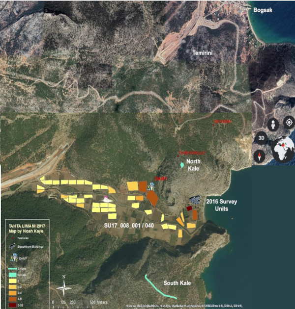
Later that same season the pedestrian team conducted a systematic survey of the open rural terrain in the narrow river valley west of Tahta Limani, beginning near the national highway (survey units SU17_008_001 continuous through SU17_008_040). Working from west to east we drew up a gridded survey of ca. 50 x 100m units and conducted a clicker survey with four walkers. Our goal was to understand how the settlement used its hinterland, and to define as much as possible the extent of the settlement westward and inland. 40 units of ca. 50 x 100 m were surveyed, using our standard method. In addition, three larger, ca. 100 x 100 m “extensive discovery” units were put down along the slopes of the north side of the valley – a scouting maneuver implemented to decrease the likelihood of overlooking important remains.
The western half of the valley was close to barren. A single diagnostic sherd was collected (interestingly, an Early Byzantine fragment of banded Cypriot Red Slip 11; SU17_008_025). No structures or clusters of pottery were detected. Hemmed in by tall peaks on all sides the archaeological record of this drainage basin is likely obscured by alluvial deposition. The “extensive discovery” portion of our study, which set walkers off scrambling through tree cover and agricultural terraces in order to scout for remains along the northern edge of the valley yielded limited amounts of pottery. At the foot of a dry ravine, we encountered a series of short cross walls, apparently intended to trap descending water. The largest such cross wall measured 1.86 m tall, 1.70 m across, with largest block .7 x. .44 m. Back in the valley, as we approached the remains of the Tahta Limanı settlement near the shore, the team encountered greater concentrations of ceramics (SU17_008_038 - SU17_009_040).
Temi̇ri̇ni̇
During the 2016 season the architectural team of Günder Varinlioğlu, Hilal Küntüz, and Fatih Timirli revisited the hilltop site of Temirini. The remains are situated at the crest of a hill (200m elevation) approximately 800m west of the modern village of Boğsak. The site is characterized by scattered Late Roman remains including a cave with structures, a small church, and a press complex. The team conducted a grab collection of ceramic remains which the pedestrian team processed back at the survey headquarters.
Cite this work
Researchers should cite this work as follows:
- Varinlioglu, G.; Kaye, N.; Pejša, S.; Rauh, N. K. (2023). Tahta Limanı Archaeological Survey: Processed Ceramics, 2015 and 2017. Purdue University Research Repository. doi:10.4231/Z4YN-F967
Tags
Notes
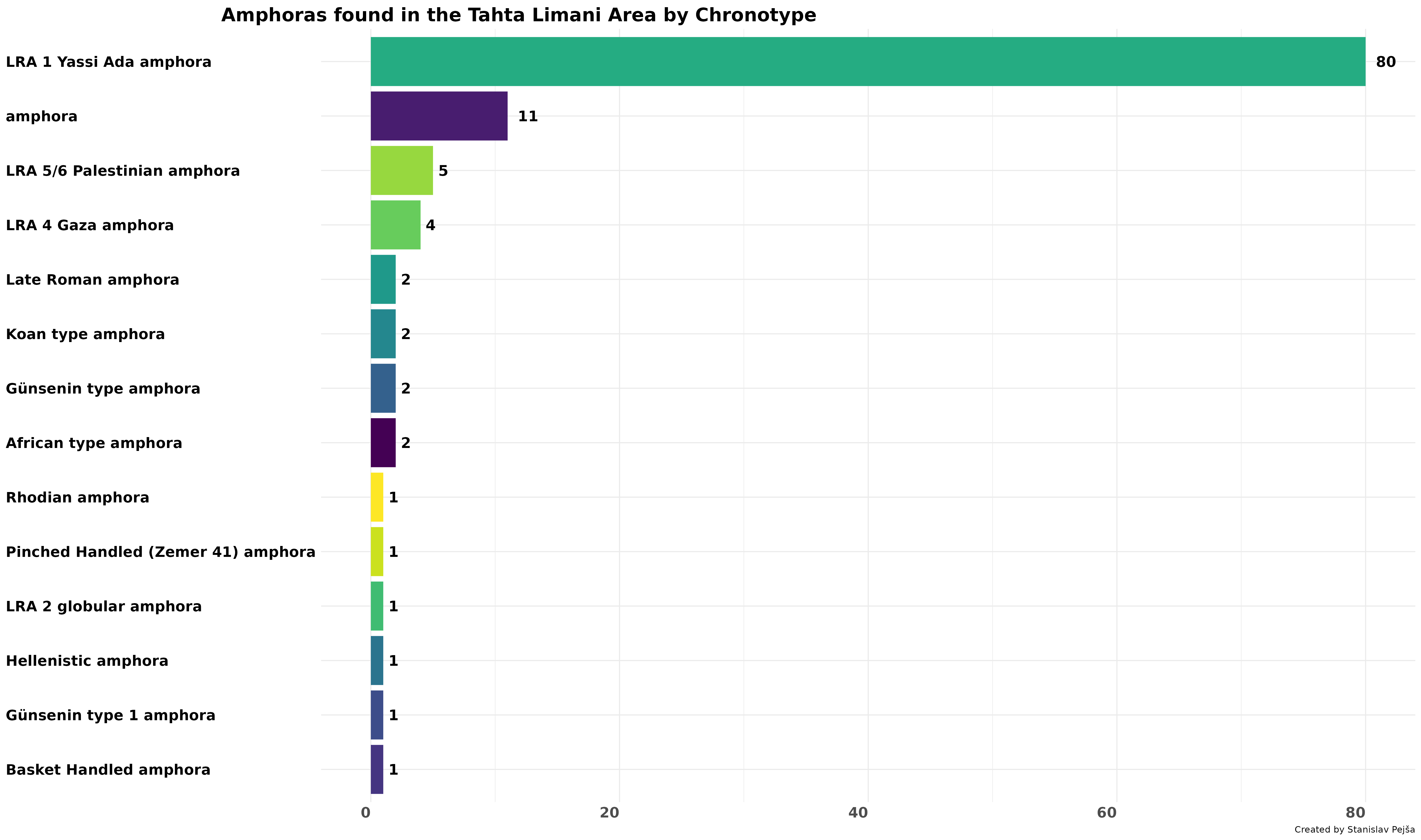
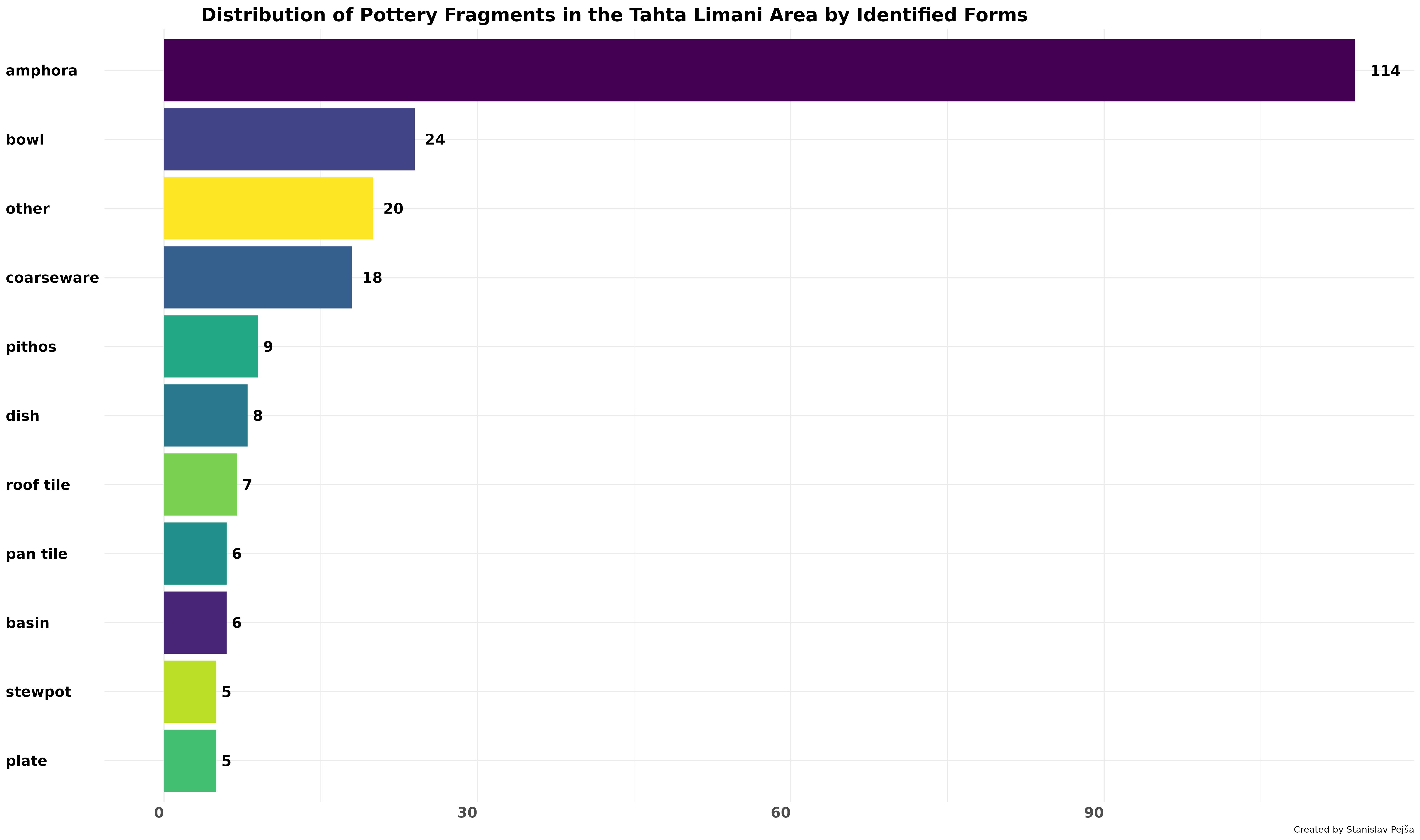
The dataset contains descriptions of 231 fragments from the Tahta Limani area.
Bogsak Archaeological Survey Team (BOGA): Processed Ceramics of the BOGA Pedestrian Survey, 2015-2019
This publication belongs to the Bogsak Archaeological Survey Team (BOGA): Processed Ceramics of the BOGA Pedestrian Survey, 2015-2019 group.